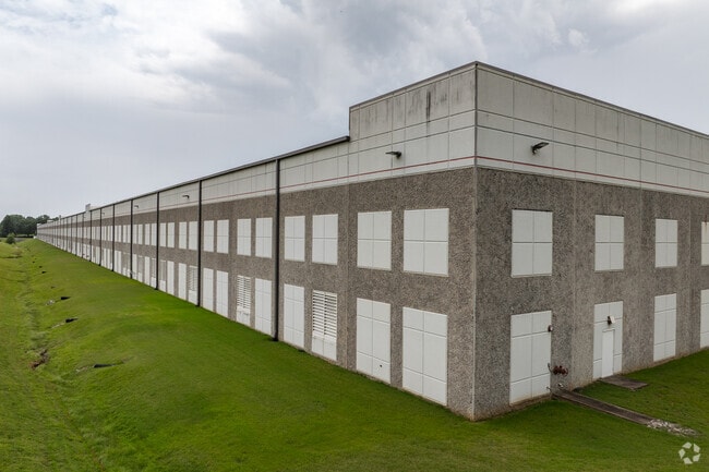
Property Record
3820 Micro Dr, Millington, TN 38053


Current Lease Availabilities
NEARBY LISTINGS FOR SALE OR LEASE
Property Detail
3820 Micro Dr
Memphis, TN-MS-AR
Industrial Dev Board
M0-125-0-0473
SS MILLINGTON RD COR MILLINGTON INDUSTRIAL PKWY (NE) TO HWY 51
Warehouse
Shelby
X
Tennessee
47157C0160G
pt3
0
38.85 AC
2025
Northwest
020221
Memphis
625,426 SF
DEMOGRAPHICS near 3820 Micro Dr
1 Mile
3 Mile
5 Mile
2024 Total Population
374
11,776
22,067
2029 Population
368
11,558
21,700
Pop Growth 2024-2029
(1.60%)
(1.85%)
(1.66%)
Average Age
45
41
39
2024 Total Households
138
4,696
8,399
HH Growth 2024-2029
(2.17%)
(1.96%)
(1.79%)
Median Household Inc
$68,181
$55,450
$51,202
Avg Household Size
2.60
2.40
2.50
2024 Avg HH Vehicles
2.00
2.00
2.00
Median Home Value
$225,471
$199,953
$196,487
Median Year Built
1977
1976
1977
Nearby Places
Map Layers
Map Styles
 Street
 Aerial
- Restaurants
- Banks
- Shops
- Fitness
- Groceries
PUBLIC TRANSPORTATION
AIRPORT
Memphis International
DRIVE
WALK
Distance
Memphis International
33 min
23.5 mi
Freight Ports
Port of Shreveport
DRIVE
WALK
Distance
Port of Shreveport
415 min
382.1 mi
Nearby Properties
Address
Land Use
TOTAL SIZE
Lot Size
Zoning
Address
Land Use
TOTAL SIZE
Lot Size
Zoning
22,232 SF
10.55 AC
R-4
Address
Land Use
TOTAL SIZE
Lot Size
Zoning
62,477 SF
1.60 AC
B-2
Address
Land Use
TOTAL SIZE
Lot Size
Zoning
17,690 SF
30.89 AC
CA
Address
Land Use
TOTAL SIZE
Lot Size
Zoning
26,350 SF
4.08 AC
P-C
Address
Land Use
TOTAL SIZE
Lot Size
Zoning
148,903 SF
13.81 AC
P-C
Address
Land Use
TOTAL SIZE
Lot Size
Zoning
76,055 SF
30.92 AC
M-1
Address
Land Use
TOTAL SIZE
Lot Size
Zoning
184.13 AC
M-2
Address
Land Use
TOTAL SIZE
Lot Size
Zoning
18,228 SF
4.41 AC
M-2
Address
Land Use
TOTAL SIZE
Lot Size
Zoning
73,893 SF
3.88 AC
B-2
Address
Land Use
TOTAL SIZE
Lot Size
Zoning
47,152 SF
7.82 AC
R-4
Address
Land Use
TOTAL SIZE
Lot Size
Zoning
1,970 SF
143.36 AC
R-4
Address
Land Use
TOTAL SIZE
Lot Size
Zoning
107.61 AC
M-2
Address
Land Use
TOTAL SIZE
Lot Size
Zoning
32,257 SF
1.75 AC
B-2
Address
Land Use
TOTAL SIZE
Lot Size
Zoning
24 AC
R-4
Address
Land Use
TOTAL SIZE
Lot Size
Zoning
27.21 AC
R-1
Address
Land Use
TOTAL SIZE
Lot Size
Zoning
10,793 SF
1.30 AC
B-2
Address
Land Use
TOTAL SIZE
Lot Size
Zoning
9.44 AC
R-1
Address
Land Use
TOTAL SIZE
Lot Size
Zoning
87,036 SF
7.14 AC
P-C
Address
Land Use
TOTAL SIZE
Lot Size
Zoning
3,634 SF
0.99 AC
B-2
Address
Land Use
TOTAL SIZE
Lot Size
Zoning
14,376 SF
1.81 AC
B-2
Address
Land Use
TOTAL SIZE
Lot Size
Zoning
65,468 SF
7.01 AC
R-4
Address
Land Use
TOTAL SIZE
Lot Size
Zoning
5,425 SF
1.36 AC
B-2
Address
Land Use
TOTAL SIZE
Lot Size
Zoning
3,045 SF
3.01 AC
B-2
Address
Land Use
TOTAL SIZE
Lot Size
Zoning
32,020 SF
10.38 AC
B-2
Address
Land Use
TOTAL SIZE
Lot Size
Zoning
59,559 SF
4.94 AC
B-2
Address
Land Use
TOTAL SIZE
Lot Size
Zoning
5,030 SF
10 AC
R-4
Address
Land Use
TOTAL SIZE
Lot Size
Zoning
2,550 SF
0.93 AC
B-2
Address
Land Use
TOTAL SIZE
Lot Size
Zoning
62,339 SF
5.22 AC
P-C
Address
Land Use
TOTAL SIZE
Lot Size
Zoning
29,104 SF
5.37 AC
R-4
The World's #1 Commercial Real Estate Marketplace
Connect with us
© 2025 CoStar Group
The information above has been obtained from sources believed reliable. While we do not doubt its accuracy we have not verified it and make no guarantee, warranty or representation about it. It is your responsibility to independently confirm its accuracy and completeness. Any projections, opinions, assumptions, or estimates used are for example only and do not represent the current or future performance of the property. The value of this transaction to you depends on tax and other factors which should be evaluated by your tax, financial, and legal advisors. You and your advisors should conduct a careful, independent investigation of the property to determine to your satisfaction the suitability of the property for your needs.